Use this teaching resource to create maps quickly and easily for your own purpose. The maps can be printed to hand out to students. The maps can be saved to your computer and re-loaded to use to demonstrate points on the interactive whiteboard. An on screen ruler can be toggled on or off.
The traditional map has self orienting roads for speed and ease of use. It has 4 figure grid references.
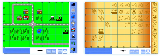
There are two versions of the treasure map. The first uses 4 figure grid references. The second uses letters and numbers for grid references.
A set of printable resources to accompany this interactive whiteboard resource can also be downloaded and contain a printable grid and cut out and stick map symbols to match the resources.
The resources are very recently completed so if any bugs or errors are found please let me know. Similarly if you have any suggestions to make them more useful please comment.
Treasure Map Maker. (4 figure grid reference)
Treasure Map Maker. (Letter-Number grid reference)
Printable Resources:
Note that this resource uses cookies to save the maps to your computer. No data is accessed or stored beyond this.
Super map resource – perfect for local area work. Any chance of adding a school picture, a church, a car park and a play park? Some people are just never satisfied!
Thanks again
Great maps thats so much, will be great for our pirate work when we go back.
The traditional map now has the extra symbols. Satisfied now 🙂 ?
Are the extra symbols on the pdf map pack yet?
Good point, I forgot about that. I’ll have them done by the end of today. Thanks for mentioning.
EDIT: The new symbols are now included.
thanks.
A brilliant resource!
Thank you – pure genius. Looking forward to trying it out.
You are a legend, I lovvvvvvvvvvvve this resource. In my experience when teaching Area and Grid References I find students find it so much easier if the northings and eastings have different values, so I’d love to see it where I could input my own values so the map template isn’t always the same or could you change either the eastings or the northings or is that being oh so picky.
I don’t understand how to get the load button to work either, can you help?
Your maps are FANTASTIC!!
Quick question … I can print them out but when I hit save on my computer nothing happens. What should I be doing to get my map to save?
Greatly appreciate the help 🙂
This Map can also be used for coordinates within maths (we have just been making maps to do both negative and positive coordinates) and is really engaging for students.
You would have to explain that the numbers correspond to values on axes and that you give the coordinates of the bottom right hand corner but I could see that this resource would have been fantastic for them, had I found it before today!
Maybe having a link to it from the Maths area as well? (Or if it’s not too much hassle – add axis labels for x and y for a “maths” version)
Thsi is brilliant, thank you! Can’t wait to use it with my students.
Great! I have tried this myself and it is GREAT!! 🙂